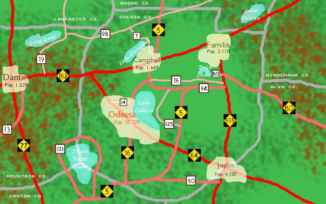
This is a more detailed area of where Familia will be located. It is located in the northeastern section of Odessa County and used to be known as "Twin Lakes" before Charlene and I took over running the town.
Red Lines = Major 4-lane highways (Black and Gold highway signs refer to Mason Island Hwy #'s)
Salmon Lines = Major 2-lane highways (Brown and White signs refer to county road #'s)
Pink Lines = Other 2-lane highways (maintained by the county instead of the island's government)
Other Cities on this map include...
Odessa (County Seat of Odessa County)
Joplin
Campbell
Dante (not shown on this map is Mt. Dante, the tallest mountain on Mason Island at 12,571' (located about 5 miles NW of Dante).
UPDATE (9/8/2015): Familia's city limits have been expanded to accommodate future additions to the city and it's population has been increased.
Details
Published:
10 years, 9 months ago
05 Jul 2015 22:54 CEST
Initial: adbb655792d6aab9c68867169da0ea05
Full Size: 9c53bd3df3c51c5b723cdd9575d35983
Large: 1e468d62e15abda8ce401d00a6c05917
Small: 4bac9d8fa3b22ccb65a4110d5013b575
Stats
162 views
2 favorites
0 comments


")