Welcome to Inkbunny...
Allowed ratings
To view member-only content, create an account. ( Hide )
newer »
cprime
cprime's Scraps (34)

Mason Island Map

Odessa County
set default image size: small | medium | wide
by cprime
United Island Colonies
+2
Sakura House and Vicinity
First in pool
Odessa County
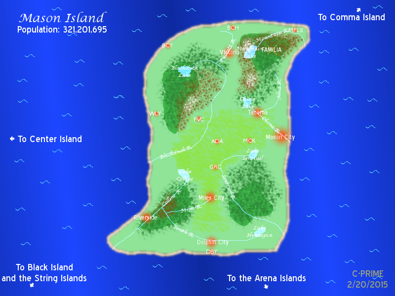
This is a map of Mason Island (originally created in 1992 as a part of a school project).  This is where most of the stories that I write take place (unless otherwise stated).

Large Red Dots with city names = Cities with 10,000,000+ residents
Smaller Red Dots with three letter labels = Cities with between 1M and 10M residents.

These cities are...

MPLS = Minneapolis
BCH = Beachside
BCY = Beach City
WLY = Wiley
FVC = Fox Valley City
MCK = McKnight
ADA = Adams
GRC = Green City
DBY = Dolphin Bay

Key to land mass features...

Light green areas = Mostly grassland
Yellowish green areas = Agricultural land (also mostly grassland)
Dark Green areas = Forest areas (shaded areas represent denser forests)
Brown areas = Hills and Mountains of between 2,000 and 5,279' in height.
White areas = Mountains of 5,280' or higher
Light Blue areas = Major rivers and lakes
Tan areas = Beaches
Gold "X" = Where Familia will be located (more on that later)

Keywords
reference 14,312, island 1,183, map 556
Details
Type: Picture/Pinup
Published: 8 years, 9 months ago
Rating: General

MD5 Hash for Page 1... Show Find Identical Posts [?]
Stats
150 views
5 favorites
7 comments

BBCode Tags Show [?]
 
ArgentFolfsky
8 years, 9 months ago
That's my IRL name. o.o
cprime
8 years, 9 months ago
Small universe isn't it. X3

Seriously though, it wasn't always known as Mason Island.  Back when I originally created this when I was 12 I called it "Dreamland" (unoriginal name is unoriginal. -_- )  A few years later, I renamed this East Island, as part of a three island chain that consisted of West, Center, and East Islands.  That name stuck for a few years until I decided to name it Mason Island, with the idea coming from the last name of my first original character (created in 1996).
ArgentFolfsky
8 years, 9 months ago
Yup, it certainly is. X3
Chocochu
8 years, 9 months ago
cool map dude!~ ^w^
Snowfirechakat
6 years ago
say i wanted to ask when you made this map did you use a tablet?
cprime
5 years, 12 months ago
No, I drew this using a mouse.  I used to have a WACOM tablet a long time ago, but I haven't used the thing in years.
Snowfirechakat
5 years, 12 months ago
awesome thanks for the info  now i can start trying GIMP out  thanks a bunch my friend
New Comment:
Move reply box to top
Log in or create an account to comment.