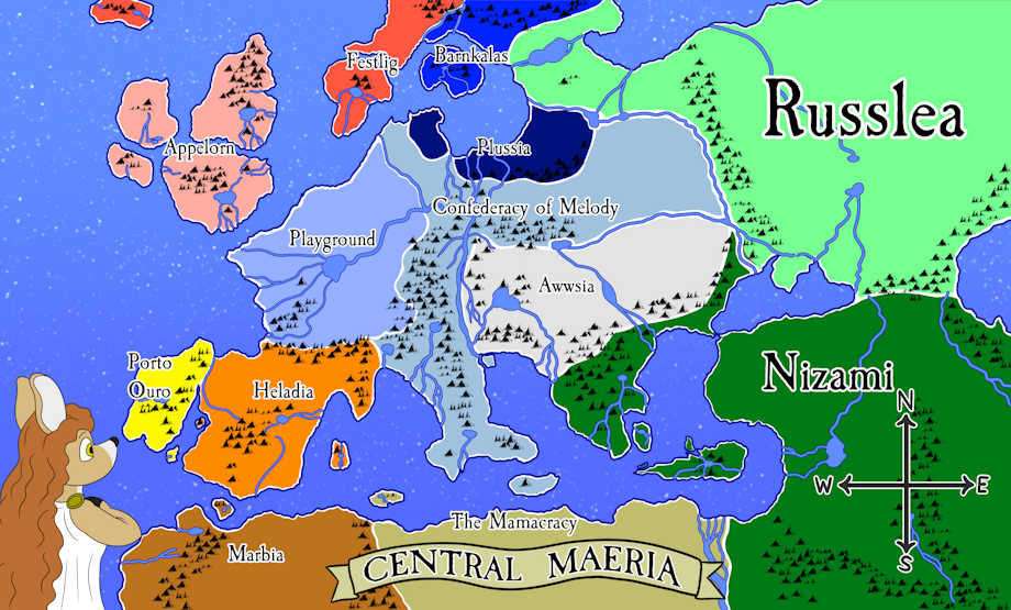
I finally got around to drawing a map of the central location of my comic setting: Children of Maeria. I haven't yet named the capitals, major rivers and oceans. I created my own brush on Clip Studio Paint that creates little mountains I drew in the Tolkien style. There's nothing fancy here, it's basically just a direct analogue of the real world circa 1800. The names are semi placeholders. The countries are roughly in the same area of their real world analogues. Some of the names are just slight deviations from the real world names. Looking at you Russlea! Actually, if people have better, kiddie sounding names for the countries that would make more sense (or perhaps would be more respectful or sensitive to the people living there), comment below or note me. I'd consider changing them. Playground and Appelorn are staying the same though. I'm pretty satisfied with them.
At this stage, I'm not sure how "close" the countries are to the cultures of its denizens. Each one is actually just one "province" of a greater unified nation. And none of the provinces engaged in imperialism like they have in our world. Though there were RARE instances of warfare between provinces on occasion. Most Maerians are united in managing the unending demonic invasions from the nether to really fight amongst themselves. In addition, Maerian society spread out from either Playground or Appelorn. Maerians colonized the other areas to restore the ecosystems (all the animals had their souls devoured by demons when the big apocalyptic war by the adults happened). While unified, each province sort of developed their own customs and cultures over the past 3000 years. Though really, there are many basic tenets that they all have in common (mandatory regression before 6, propensity for wearing diapers, worship of Mother Maeria in some way or another, and a corrupt and bratty noble class).
Visual Description: The area pretty much depicts Europe, North African, Anatolia, and Russia. The land mass distribution is roughly the same as the real world, though the shapes of each nation is different (in some cases). Here is a short description of each nation along with their color on the map:
Appelorn - Pink - United Kingdom - Instead of one big island where Wales, England, and Scotland would join, there are four islands instead. (Ireland's equivalent still has its own island)
Playground - Baby Blue - France - Basically just looks like France. Sunnyside is its capitol and the main story of my comic takes place here.
Heladia - Orange - Spain - Looks pretty similar to Spain. There is even an island in the place where the Belaric Islands would be.
Porto Ouro - Yellow - Portugal - A little more sperated from "Spain" than the real Portugal. Basically a peninsula. Half the landmass of Heladia.
Confederacy of Melody - Teal - Holy Roman Empire / Confederation of the Rhine- This place is large and snakes from the north of the continent to the South where Italy would be. It includes a number of smaller historical nations that would make up Germany eventually. I didn't represent nations like Piedmont Sardinia, Sicily, and Naples. They are all part of this "Province" for all intents and purposes.
Plussia - Dark Blue - Prussia - Split into one area closer to Playground and another area closer to the east. The piece closest to the east is three times the size of the other piece. The Confederacy of Melody is the province splitting it. Prussia was the major German state that would manage to unify Germany in the 1870s.
Festlig - Red - Denmark, Norway, and Iceland - Festlig is split off from the main continent of Central Maeria in this world as opposed to bordering Germany in the real world.
Barnkalas - Blue - Sweden - Made up of an island and part of the Scandinavian peninsula. Bordering Russlea to the east.
Awwsia - Whitish Grey - Austria (and the area of Hungary and parts of northern Slavic and Greek territories in our world)
Russlea - light green - Russia - Spreading from the equivalent of Finland to the west down to the Caucuses Mountains in the South and disappearing off the eastern side of the map. Bordered to the west and south by mountain chains with a large flat steppe in between.
Nizami - forest green - Ottoman Empire - Occupying southern Slavic and Greek territories (in the real world) a large island in the inland sea, Turkey (Anatolia), and stretching down to the equivalent of the Nile and the Middle East.
The Mamacracy - Tan - Egypt / The Mamelukes - Basically occupying the same space as Egypt. Also occupying an island close to Heladia's Belaric Islands equivalent.
Marbia - Brown - Morocco - Basically Morocco with a small island at the straight of Gibraltar.
An image of Maeria herself with long red hair is staring at the map clutching a hand to her chest. She is an adult deer female wearing a greek looking goddess dress with a gold clasp on the shoulder. In the bottom right corner of the map is a simple compass depicting North, South, East, and West.
Keywords
female
1,107,946,
deer
31,008,
mother
11,681,
mountains
2,128,
map
587,
satire
370,
napoleonic
90,
europe
89,
children of maeria
89,
compass
67,
rivers
32,
seas
32,
oceans
9
Details
Published:
2 years, 3 months ago
11 Apr 2023 03:51 CEST
Initial: 27704ab44a2dd4b829a1b2a59e09d083
Full Size: 35561b16fc2c68ede60d47497bd19c4f
Large: 38896a432f8097aa0fe34ea94a4ad31d
Small: ae3fe37f7b9fd4949c2431594337c9dc
Stats
69 views
8 favorites
5 comments
