Welcome to Inkbunny...
Allowed ratings
To view member-only content, create an account. ( Hide )
Jonathan & Bertha Colored
« older newer »
MviluUatusun
MviluUatusun's Gallery (170)

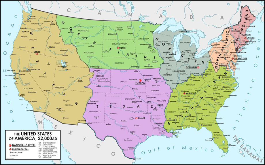
The United States, 22,000 A. D.

Sketch of Ashtlaka

Medium (920px wide max)
Wide - use max window width - scroll to see page ⇅
Fit all of image in window
set default image size: small | medium | wide
Download (new tab)
Jonathan & Bertha Colored
Amanda's Character Sheet
The story I'm working on takes place in the current United States of America, although they call it the United Provinces of America, 20,000 years in the future. Things aren't quite what they are today but, they are similar. Unlike we did, they chose natural boundaries to determine the boundaries of the different provinces, even going so far as to merge certain of our states into one state rather than one or two states. They also chose to give the cities and provinces similar but different names. For example, Georgia became Gargia, Carolina became Carpolina and Florida became Flamingo. Atlanta is now known as Catlanna, Tampa is now Tapir and New Orleans is now Gnawluns (not much of a different pronunciation. LOL.) In the attached map, however, the state and city names haven't been changed but, I intend to do that as soon as I can. If you'd like to help make suggestions in your comments and I'll consider them. There is two major rules. 1) The new name needs to sound similar to, if not exactly like, the original name and 2) the new name must have an animal, animal sound, animal body part, animal action, plant name, plant part (i.e. leaf, bark, trunk, etc.), geographical name, or meteorological name included.

I can't remember the name of the artist who did this map for me as it was done over a year ago. All I can remember is that I had seen several maps that he'd done and requested that he do this one for me. If you are the artist who drew this for me, and can prove it, let me know and I'll give you proper credit. (I hate uploading a drawing without giving the artist the credit he or she deserves.)

Keywords
Details
Type: Picture/Pinup
Published: 5 years, 8 months ago
Rating: General

MD5 Hash for Page 1... Show Find Identical Posts [?]
Stats
139 views
6 favorites
8 comments

BBCode Tags Show [?]
 
fox3379
5 years, 8 months ago
Topekas the national capitol?..... well it is pretty much the center of the country,but not sure if they would have much of an infrastructure imo. nice map either way :-)
MviluUatusun
5 years, 8 months ago
Thanks.  It was the central location that made me decide to do that.  Also, in this time frame, the central government is as the founding fathers of our country originally intended for it to be, relatively weak but the location of the important governmental bureaus to insure proper running of the country as a whole.  The districts, the different colored areas of the map, are quasi-independent countries within the country and are where the true running of the country takes place the way the states were originally supposed to be where the country was run. Also, while flight has been around for close to a hundred years in this time line, flight is discouraged within the districts as much as possible to free up the airspace for military usage when necessary.  However, if you live in the Texas district, for example and wish to travel to the Western district, you have the option of flying, taking a train, taking a bus or driving your own vehicle.
fox3379
5 years, 8 months ago
interesting kinda reminds me of an RPG I used to play called "Shattered Union" basically its the future and after an election of an unpopular candidate for president, Texas succeeds from the union,then the southern states,then the Western states as well and on. so pretty much you pick a regoin and try to take over the other regions  of the former united states.
MviluUatusun
5 years, 8 months ago
Interesting.  The reason that the regions/districts are set up is to take the power away from the central government.  It's kind of like a chain of command.  The weakest part of the chain is the local(city) government, then the county, then the province(state), the region and, finally, the federal government.  This set-up prevents the federal government from micromanaging the country and puts the governmental power back in the hands of the states where it was originally intended to be.
RileyRivers
5 years, 7 months ago
MviluUatusun
5 years, 7 months ago
Well, actually, only two regions are exactly alike.  My Northern Region and the New England Region.  Also, the state borders are different somewhat.  I also need to make a few changes to this map to more closely resemble the way I see the UPA shown in the map.  For example, the Oklahoma panhandle what is shown as New Mexico would go to Texas; the northern border of Utah would be an extension of the northern borders of California and Nevada; and the northern border of Arkansas would go straight across to the Mississippi River.  There are several other border changes but those are the most noticeable ones.
RileyRivers
5 years, 7 months ago
It's more or less the Economic Cultural Zones of America.
MviluUatusun
5 years, 7 months ago
Oh, I see.  I didn't know that.  My regions are, basically, political regions where the people living there have more in common than with other regions.  This is also the country in a story I'm working on which takes place 20,000 years in the future.
New Comment:
Move reply box to top
Log in or create an account to comment.